
Need segment-level traffic data?

Identify traffic patterns street by street and analyze the exact corridors that matter to your project.
Get insights →
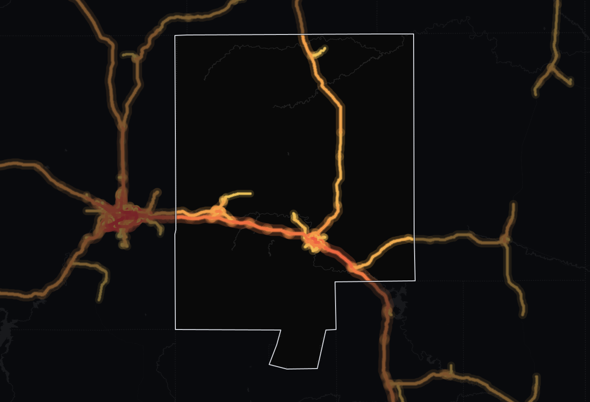
Traffic heat map of Converse County, Wyoming: 374 miles of roads shaded from blue (light) to red (heavy traffic), busiest on Yellowstone Highway and 4th Street

Converse County, Wyoming Traffic Counts

Our Converse County, Wyoming traffic data covers 1,463 road segments over 374 road miles, with an average segment of just 1,349 ft. Trips here are among the 5 longest of any county in Wyoming. Whether you are evaluating a new retail location, planning routes or assessing infrastructure, these numbers replace guesswork.
Data sourced from TrafficZoom's proprietary analytics platform.
Data current as of:
Q3 2026
Updated:
September 29, 2026
Find my place
total traffic icon

Total Traffic Volume & Performance in Converse County, Wyoming

Traffic

The average number of vehicles that travel each day over any road in the road network.

vehicles per day2,722
Trucks

The percentage of the total traffic volume composed of heavy vehicles.

15.8%
Average travel time

The average time of travel averaged among all vehicles traveling on the road network.

39.1 min
Drivers’ average age

Average age of residents in the geographic areas where the vehicle trips originated.

48.2 yrs
Drivers’ average income

Average income of residents in the geographic areas where the vehicle trips originated.

$79,415

A typical monitored road in Converse County, Wyoming sees 2,722 vehicles per day, while its 374 miles of monitored roads together handle 840,969 vehicle-miles traveled per day (≈307 million per year). Trucks are 15.8% of traffic, close to the 17.9% across Wyoming.

Longer trips than 82% of counties in Wyoming

At 2,722 vehicles per day, the average monitored road in Converse carries 25% less traffic than the state average of 3,650, suggesting less demand on each road - less drive-by exposure for retail, but easier access for deliveries. Across the whole network, that travel is about 3.9% of Wyoming's statewide total. Converse carries less traffic than 59% of counties in Wyoming.

The average trip takes 39.1 minutes, 13% higher than the state level. 82% of counties in Wyoming have a shorter average travel time than Converse's 39.1 minutes.

Highway vs. Non-Highway Traffic Analysis

highway traffic icon

Highway Traffic in Converse County, Wyoming

Trafficvehicles per day2,860
Trucks17.5%
Average travel time51.6 min
Drivers’ average age48.0 yrs
Drivers’ average income$79,901

The vast majority of driving in Converse County, Wyoming happens on highways: 81% of all vehicle-miles. The average highway carries 2,860 vehicles per day, 8% more than the average non-highway road in the same area, which carries 2,658 vehicles per day.

With 55% of the road miles (207 miles in 466 segments), highways punch above their length, carrying 680,882 vehicle-miles traveled per day (≈249 million per year).

63% of counties in Wyoming move less traffic on their highways.

More highway trucks than 68% of counties in Wyoming

Highway truck concentration here runs 25% lower than the state average, at 17.5%. Highways here mostly serve passenger trips, so local access matters more than long-haul routing for logistics operators.

Converse's highway truck share (17.5%) is higher than 63% of counties in Wyoming. By raw truck volume, Converse carries more highway trucks than 68% of counties in Wyoming.

non-highway traffic icon

Non-highway Traffic in Converse County, Wyoming

Trafficvehicles per day2,658
Trucks8.2%
Average travel time33.3 min
Drivers’ average age48.4 yrs
Drivers’ average income$78,722

At 19% of vehicle-miles, local roads carry a smaller share of the traffic in Converse County, Wyoming than highways. A typical local road sees 2,658 vehicles per day.

Local roads make up 45% of the monitored road miles (167 miles in 997 segments) but carry less than their share of travel: 160,087 vehicle-miles traveled per day (≈58.4 million per year). The truck share on non-highway roads is 8.2%.

Drivers from higher-income areas than 73% of counties in Wyoming

The concentration of trucks on non-highway roads is 53% lower than on highways.

Trip origins here have higher average income than 73% of counties in Wyoming. 55% of counties in Wyoming have an older driver population than Converse.

Time-of-Day & Seasonal Patterns

peak hours icon
Peak Traffic Windows
Weekday peaks:
A long morning plateau from 7:00 AM to 12:00 PM and PM peak 3:00 PM–6:00 PM, with volumes reaching approximately 74% higher than the daily average.
Weekend traffic:
Weekends are somewhat quieter: volumes run about 18% below weekday levels, the usual weekend dip.
seasonal traffic icon
Seasonal Fluctuation
Busy season:
June–August is the high season, with volumes +18% versus the annual average.
Lowest month:
January is the quietest month, with volumes -24% versus the annual average - the usual winter low.

Data Finding: Hourly & Seasonal Patterns

In Converse County, Wyoming, the peak hour concentrates about 7% of the day's traffic, and there is a strong seasonal swing of +18% in high season.

Converse County vs. Wyoming Traffic Comparison

The average daily traffic per road sets Converse County apart: 25% below the Wyoming average. Its highway truck share is also 25% below.

MetricConverse CountyWyoming averageDifference
Traffic2,7223,650-25.4%
Truck % (Total Traffic)15.8%17.9%-11.9%
Truck % (Highway)17.5%23.3%-24.8%
Avg. Travel Time39.1 min34.5 min+13.4%

How Converse County compares

Converse County against nearby counties

Converse County tracks the 4 areas around it closely - no measure in this table sets it far apart from the areas immediately next to it, though it has the second busiest roads of the five. The same kind of road, simply more of it: traffic per road matches the areas around it while the network itself is larger.

Converse County and the 4 nearest county-level areas by centroid distance, with the Wyoming average for scale.
AreaAverage daily trafficTruck shareDaily vehicle-milesAverage travel timeCongestion ratio
Converse County2,72215.8%840,96939.1 minN/A
Niobrara County, Wyoming1,37014.8%113,38358.9 minN/A
Weston County, Wyoming1,80810.5%173,66148.4 minN/A
Natrona County, Wyoming6,7359.8%1,773,24937.3 min18.0%
Platte County, Wyoming1,38716.6%514,87839.6 minN/A
Wyoming average3,65017.9%N/A34.5 min11.5%

Converse County ranked within Wyoming

Converse County sits in the top quarter of the Wyoming field on average travel time, at #5 of 23.

Converse County ranked among 23 county-level areas in Wyoming (1 = highest); measures without data in every county rank a smaller field, down to 20.
MeasureConverse CountyWyoming rank
Traffic volume (AADT)2,722#14 of 23
Highway vehicle-miles per day680,882#8 of 20
Truck share on highways17.5%#8 of 20
Highway trucks per day502#7 of 20
Average travel time39.1 min#5 of 23
Average driver income$79,415#7 of 23
Average driver age48.2 yrs#13 of 23

Busiest roads in Converse County, Wyoming

On their busiest stretches, the three busiest roads in Converse County carry 11,515 vehicles a day on average, 4.2 times the typical road in the county (2,722).

Yellowstone Highway is the busiest road, at 12,004 vehicles a day, 685 of them trucks (5.7%). I 25 carries the most trucks, 1,463 a day (18.3% of its traffic), although it ranks #4 for all traffic.

Few trucks use Center Street: 5.1% of its traffic, under half the county's 15.8%.

I 25 carries longer journeys than most roads here, with a median trip of 51.2 minutes against 39.1 county-wide.

Ranked by daily traffic (AADT)

Cars and light vehiclesTrucks
1Yellowstone HighwayPrimary road · 12,004vehicles685trucks · 5.7%
Road class
Primary road
Median trip time
33.1 min
Drivers’ median age
48.2 yrs
Drivers’ average income
$74,082

Yellowstone Highway peaks at 12,004 vehicles a day, 4.4 times the county average; trucks are 5.7% of it, below the county-wide 15.8%.

24th StreetPrimary road · 11,439vehicles597trucks · 5.2%
Road class
Primary road
Median trip time
35.5 min
Drivers’ median age
48.2 yrs
Drivers’ average income
$85,923

4th Street carries 4.2 times the county average at its busiest, 597 of them trucks (5.2%, below the county-wide 15.8%).

3Center StreetPrimary road · 11,101vehicles568trucks · 5.1%
Road class
Primary road
Median trip time
30.9 min
Drivers’ median age
47.9 yrs
Drivers’ average income
$79,652

Center Street carries 4.1 times the county average on its busiest stretch, where the median trip lasts 30.9 minutes.

4I 25Motorway · 8,005vehicles1,463trucks · 18.3%
Road class
Motorway
Median trip time
51.2 min
Drivers’ median age
48.6 yrs
Drivers’ average income
$78,213

At 2.9 times the county average, I 25 draws drivers from neighborhoods averaging $78,213 in household income.

5Richards StreetSecondary road · 6,698vehicles297trucks · 4.4%
Road class
Secondary road
Median trip time
36.4 min
Drivers’ median age
48.2 yrs
Drivers’ average income
$76,891

The busiest stretch of Richards Street carries 2.5 times the county average; trucks are 4.4% of it, below the county-wide 15.8%.

Ranked by trucks per day

Cars and light vehiclesTrucks
1I 25Motorway · #4 by traffic8,005vehicles1,463trucks · 18.3%
2Yellowstone HighwayPrimary road · #1 by traffic12,004vehicles685trucks · 5.7%
34th StreetPrimary road · #2 by traffic11,439vehicles597trucks · 5.2%
4Birch StreetPrimary road · 6,346vehicles583trucks · 9.2%
Road class
Primary road
Median trip time
28.4 min
Drivers’ median age
50.2 yrs
Drivers’ average income
$70,066

Trips on Birch Street are short, a median 28.4 minutes against 39.1 county-wide, so it mostly serves local errands and commutes.

5Center StreetPrimary road · #3 by traffic11,101vehicles568trucks · 5.1%
How to read these road counts
  • The first number is AADT, annual average daily traffic: the vehicles passing a point on an average day, both directions combined and trucks included. On a divided highway both carriageways are added together.
  • Traffic changes along a road, with more near interchanges and towns and less in open country. Every figure for a road describes its busiest stretch in the county, so the two rankings show the same numbers for the same road.
  • The second number is the trucks on that stretch, a part of its AADT. The bar splits the AADT into cars and light vehicles (blue) and trucks (amber).
  • See segment-level AADT for any road on TrafficZoom.

Data Sources & Methodology

The data presented on this page is derived from TrafficZoom's proprietary analytics platform, which aggregates and normalizes information from multiple sources, including:

Mobile device location data (anonymized and aggregated)

Road sensor networks and traffic counters

Historical traffic pattern databases

Public traffic count programs published by the

ConverseDepartment of Transportation

Demographic Baseline for O-D Modeling

U.S. Census Bureau
All metrics represent estimates based on statistical modeling and are intended for strategic planning purposes.
link arrow icon
Data current as of:
Q3 2026

Explore further

TrafficZoom platform

— street-level analytics and custom corridor reports.

Map AI

— demographics, housing and mobility data.

Counties near Converse County

The same traffic breakdown for the areas closest to Converse County, Wyoming.

Need segment-level traffic data?

Identify traffic patterns street by street and analyze the exact corridors that matter to your project.
